|
Met Office Shipping Forecasts
0600 Wednesday 15th April |
| Plymouth |
| Gale Warnings |
|
| Wind |
Southerly veering southwesterly, 4 to 6. |
| Weather |
Occasional rain and fog patches, then showers. |
| Visibility |
Moderate or good, occasionally very poor at first. |
| Sea |
Moderate or rough, occasionally very rough later. |
|
| Lundy |
| Gale Warnings |
|
| Wind |
South or southwest 4 to 6. |
| Weather |
Rain and fog patches, then squally showers. |
| Visibility |
Moderate or good, occasionally very poor at first. |
| Sea |
Moderate or rough, becoming rough or very rough later in west |
|
|
Local Inshore Waters Forecast
Lyme Regis to Land`s End including the Isles of Scilly |
| 0600 Wednesday 15th April |
| 24 Hour Forecast |
| Wind |
South veering southwest, 4 to 6. |
| Weather |
Occasional rain, drizzle and fog patches at first, then showers. |
| Visibility |
Moderate or good, occasionally very poor at first. |
| Sea State |
Slight or moderate at first in east, otherwise moderate or rough, occasionally very rough later near Isles of Scilly. |
| Outlook for following 24 hours |
| Wind |
Southwest 3 or 4, occasionally 5 at first, backing south later. |
| Weather |
Showers |
| Visibility |
Moderate or good. |
| Sea State |
Moderate or rough, occasionally very rough at first near Isles of Scilly. |
|
|
Local weather info also available from Falmouth
Coastguard on 01326 317575. Please tell them if you are setting
off in a boat or on a remote cliff-climbing expedition.
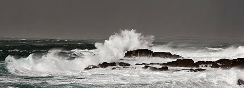
Swell Prediction for Sennen Bay (Height & Direction ) - High Water Time- Height
Updated Daily |
Wednesday 15th April
West-southwesterly swell around 9ft or slightly more today, becoming westerly around 12ft tomorrow.
Westerly swell around 9ft on Friday easing to around 6ft or slightly more on Saturday.
Smallish west-northwesterly swell on Sunday becoming generally westerly between 3 and 6ft on Monday.
Long-period west-northwesterly swell around 6ft on Tuesday. |
| Sevenstones Lightship Wednesday 0900; swell 9ft. Lands End wind:- S.southwest 13mph |
| Wednesday 15th |
9ft west-southwesterly |
0354; 1618 |
16`7" |
| Thursday 16th |
12ft westerly |
0434; 1655 |
17`7" |
| Friday 17th |
9ft westerly |
0513; 1734 |
18`4" |
| Saturday 18th |
6ft+ westerly |
0553; 1813 |
18`7" |
| Sunday 19th |
3ft+ west-northwesterly |
0635; 1855 |
18`7" |
| Monday 20th |
3-6ft westerly |
0718; 1938 |
18`4" |
| Tuesday 21st |
6ft west-northwesterly long period |
0803; 2024 |
17`4" |
Sennen Bay
Further swell outlook - updated daily - long range forecasts not necesssarily accurate; regularly change significantly, and useful as a guide only ! |
| Wednesday 22nd |
3-6ft west-northwesterly |
0852; 2116 |
16`4" |
| Thursday 23rd |
3ft west-northwesterly |
0950; 2220 |
15`4" |
| Friday 24th |
3ft west-northwesterly |
1105; 2343 |
14`8" |
| Saturday 25th |
3-6ft westerly |
1240 |
13`8" |
| Sunday 26th |
3ft west-southwesterly long period |
0112; 1359 |
14`8" |
| Monday 27th |
3-6ft nortthwesterly |
0223; 1459 |
15`4" |
| Tuesday 28th |
6ft northwesterly |
0319; 1546 |
16`1" |
|
Current Actual Weather at
Land`s End
click here
( courtesy John Chappell ) |
| Weather Outlooks - normally updated Sundays and Thursdays. |
| Sunday 12th April |
| A showery week - breezy at times. |
| Tuesday 14th |
Rain then showers in fresh south or southeasterlies. |
| Wednesday 15th |
Showers in moderate or fresh southwesterlies. |
| Thursday 16th |
Showers in southwesterly breeze. |
| Friday 17th |
Showers in southwesterly breeze. |
| Saturday 18th |
Showers in moderate west or northwesterlies. |
| Sunday 19th |
Mainly fine in north or northeasterly breeze. |
| The above information is given in good faith ~ absolutely no responsibility can be accepted for any actions taken on this information. |
|
|